| |
Boubín |
The peak (1362 m) is covered by Boubínský forest, which is the third oldest nature preserve in the Czech Republic and whose area is 620 ha. The aged trees are 300-400 years old and some of them are unusually distorted. On the peak of Boubín, there lies a granitic obelisk and there leads a 3,8 km long instructive trail around the forest. You can find the Boubínské lake – a romantic artificial reservoir dating from 1833 – on the Kaplický brook. The best way to get to Boubín is from the car park on the upper end of Zátoň (a near railway station). |
|
|
Čertova stěna |
The rocky locality Čertova Stěna is situated above the Vltava river under Loučovice. It offers an impressive view of the surrounding scenery. The scenery is most beautiful in autumn with its mountains covered by trees with coloured leaves. TheVltava river runs through the stony bed called the Čertovy Proudy (Devil's Streams). The highest peak is called Čertova kazatelna (the Devil´s Pulpit), also called Strašidelník. The scenery was the source of inspiration for Eliška Krásnohorská who composed the libretto for the opera Devil´s Wall by Bedřich Smetana. The legend says that Mr Vok of Rožmberk had almost drown in those wild waters. As his reward for his rescue, he started to built the vyšebrodský cloister, but this idea was hated by the devils who tried to thwart his intention by scattering huge stones to the river and thus forming a dam. This dam should have been used for flooding the cloister. This task had to be completed until the dawn, but it was not managed because the cock crowed too early. Through the canyon, there is a track which leads against the stream to Loučovice, or down the stream to Vyšší Brod. You can access the Čertova Pulpit from the car park on the right side of the road leading from Lipno to Vyšší Brod. |
|
|
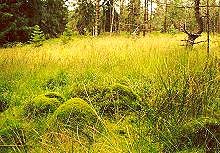
Chalupská slať |
The moorland with a quaint lake is situated near the village Borová Lada (cca 20km northwestern of Volary). The moorland is 136ha large, the maximum depth is 7m. It is partly covered by scrub and some rare plants; however, it is partly damaged because of the mining from the 19th century. The moorland is a nature preserve accessible by the wooden path leading to the lake. You can find the Information centre of the national park at the entrance. |
|
|
Jezerní slať |
It is a spacious moorland near the village Kvilda on the watershed of Vltava and Otava. This place was proclaimed as a nature preserve in 1933 and it covers an area of 120 ha. There can be found all species of platns which are characteristic for the Bohemian moorlands. You can access the preserve by a path leading from the car park, and then by the wooden path. On the edge of the fen there is an observation tower. |
|
|
Libín |
On the peak Libín (1096m), situated cca 4km southern of Prachatice, there is a stone observation tower (27m) dating from 1883. There is an impressive circular view from it and particular in a nice weather when you can see the peaks of the Alpes as well. On the northern hillside there is a nature preserve – a forest ( 69ha). In the village Libínské Sedlo (Fefry) you can find the late-Gothic church of Saint Anne dating from the 16th century and several lateral stone buildings.
|
|
|
Medvědí stezka |
This instructive trail leads through the wooded slopes of the peak Perník (cca 7 km nothwestern of Nová Pec). The trail leads from the railway station Ovesná past the rocky formations Bear stone, where the last Bohemian bear was shot in 1856, to the railway station Černý Kříž (Black Cross). The trail is lined by rocky formations which were formed by weathering of coarse granite. |
|
|
Moldaublick |
The observation tower built in 1967 is situated on the northeastern hillside of Sulzberg ( a peak near the German frontier – in Germany). It was originally a derrick. It is 25m high and there is an iron staircase of 137 stairs to the top of the tower. You can see for instance the Lipenská dam, Boubín or Vítkův Kámen (Vitek's Stone) from the tower.
|
|
|
Multerberské rašeliniště (Multerberk moorland) |
This moorland lies in the municipality of Přední Výtoň, approximately 2km eastern of the village Pasečná on the left side of the road leading from Pasečná to Spáleniště. On the western edge, the moorland changes into wet meadows and the peat is 200 – 310 cm deep. On the surface of the moorland, there were found rare species of insect, for example the ground-beetle Abonuj ericeti and also the endangered ground-beetle Carabus menetriesi. In winter, the endangered european elk can be seen here. |
|
|
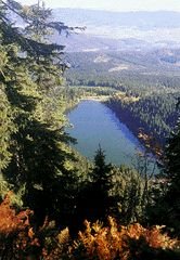
Plešné jezero (Plesne Lake) |
The lake lies approximately 7 km southwestwards (air distance) of Nová Pec on the border with Austria. It lies in the middle of the forests and it is said to be the most splendid lake of the 8 Bohemian Forest´s lakes. This lake is 18m deep and the water from it used to be used as a source for the Schwarzenberk canal. On the steep cliff above the surface of the lake, there is a memorial of the writer Adalbert Stifter from the 19th century. The memorial is 13m high and it consists of granite blocks. There are impressive views of the Vltava river valley from this place. You can reach the lake and the memorial by the tourist paths leading from Nová Pec. |
|
|
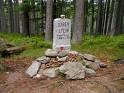
The Vltava river spring |
The Vltava river is the longest river in the Czech Republic. It springs in the altitude of 1172 m. The upper stream, called the Black stream, was closed for public for 40 years because it flows through the frontier area. Above the way leading to the spring, there was built a cottage in 1922, which was used as a prisoner camp towards the end of the War and destroyed in the 60s. The surrounding moorland is a nature preserve, the watershed of the Black and Northern Seas ( the brook Reschbach). |
|
|
The Schwarzenberg floating canal (Jelení) |
Near the village Jelení, established in 1794, there is a remarkable technical monument – a 429m long tunnel of the Schwarzenberg floating cannal dating from 1823. The canal is 45 km long and it connects the river-basins of the Vltava and the Danube rivers. It was built in the years 1789-1822 as a waterway for the log wood from the Bohemian deep forest to the Vltava River and further to the Danube River. A part of the canal is newly rebuilt and maintained. This canal is one of the first-rate technical site. There are tourist paths around. You can reach it on foot or by bike from Nová Pec or from Nové Údolí (New Valley). |
|
|
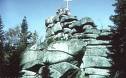
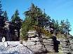
Třístoličník |
This peak is 1302 m high and in belongs to the most favourite destinations in the Bohemian Forest. It is situated on the Czech-German border and not far from it, there is a place where the frontiers of the three states – the Czech Republic, Germany and Austria connect, so-called Trojmezí (Three Landmarks Place). On the peak, there is a formation of 3 granite boulders into which the stairs are carved and it has functioned as an observation tower since the 19th century. There is a magnificent view of Bavorsko and it is said that when the sky is cloudless you can see with field glasses the turrets of the Frauenkirche in Munchen. You can reach Třístoličník via the tourist path from the New valley or you can walk there from Trojmezí on the ridge. The motorists can take take the road from Germany from Haidmuhle to the car park under the peak.
|
|
|
|
|
| |